
The economic think-tank in its earlier projection had suggested that the Indian economy was likely to grow at 5.7 per cent in 2014-15.

The latest forecast, given by Earth Sciences Minister Jitendra Singh, was a downward revision from a previous forecast of 93 per cent given at the outset of the monsoon in June, but was nowhere near as bad some farmers had feared.

The south-west monsoon arrived over Kerala after a delay of four days and its progress since then has been unsatisfactory. Forecasts of rainfall for June and July are not good, CMIE said.

Union Home Minister Amit Shah on Wednesday said the Centre had sent multiple advance warnings to the Kerala government about possible floods and landslides in the state, starting as early as July 23, and nine National Disaster Response Force (NDRF) teams were rushed to the state the same day.

Heavy waterlogging was witnessed in several towns and cities, while roads were closed in rural areas on Friday morning due a heavy spell.

Global experts last week gave the same forecast.

Intense spells of rain are likely to continue in the districts of Thane, Raigad and Mumbai during next four hours, the India Meteorological Department (IMD) said.

India's leading commodity exchange, National Commodity and Derivatives Exchange (NCDEX), and private weather forecasting company Skymet took a significant step towards launching the country's first tradeable weather index on Monday (August 14) by entering into an agreement to deepen their understanding of the impact that weather has on agricultural commodities. The memorandum of understanding (MoU) between NCDEX and Skymet is a profound step in the direction of linking farmers with the weather in a scientific way, according to an official statement. Sources indicate that NCDEX and Skymet will conduct workshops and seminars across the country to educate farmers about how they can scientifically use weather forecasts to hedge risks.

The official India Meteorological Department (IMD) and the private Skymet Weather Services have made widely divergent monsoon forecasts.
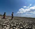
Any long dry spell could cause moisture stress in the standing crop during the crucial maturing stage and also make it prone to pest and disease attacks.

The Odisha government has asked all the district collectors to remain prepared for any eventuality, and directed the administration to evacuate people from low-lying areas in the event of heavy rain.

Colombo weather forecast remains somewhat ominous, with a 70% chance of rain predicted for Sunday morning

Climate change has hampered the ability of the forecasting agencies to accurately predict severe events and weather bureaus across the world are focusing on augmenting the observational network density and the weather prediction modelling to improve predictability, India Meteorological Department (IMD) Director General Mrutyunjay Mohapatra has said.

The arrival of the June-September rains has been delayed.

Weather.com has predicted Thunderstorms with an 80 percent chance of rain for the region of Kandy on Saturday.

The IMD defines a normal monsoon as one which delivers between 96 and 104 per cent of the 50-year average rainfall for the season.

The southwest monsoon is expected to reach Kerala during the next two to three days, marking a sluggish start to the seasonal rains that are the lifeline of India's agri-based economy.

In a statement, it said 198 properties in the state were partially damaged and 30 houses completely destroyed in the rains from July 31 to till date.

With the flood threat continuing to loom large over the valley, the Army has started the evacuation process in Srinagar as the city experienced fresh rainfall on Tuesday.

The deep depression over central Bay of Bengal is likely to intensify into a cyclonic storm by Sunday evening and after changing course in a northeastward direction from northwest.
Researchers claim to have finally solved the riddle as to why some El Niqo events cause the Indian monsoon to fail while others do not, a finding which may lead to more accurate forecasts of drought and floods.
The onset of the southwest monsoon is being keenly watched this year as it may provide an early sign regarding its progress over the Indian subcontinent, particularly when El Nio is expected to rear its head during the latter half of the season.

Rajasthan's three districts -- Jalore, Sirohi and Barmer -- are reeling under a flood-like situation due to heavy rainfall caused by cyclonic storm Biparjoy, an official said on Sunday.

Skymet says the IMD ignored the required criterion of two days of necessary rainfall to declare a proper onset of monsoon, reports Sanjeeb Mukherjee.

The cyclone ravaged adjacent coasts of the state and Bangladesh between Sagar Island and Khepupara, near the southwest of Mongla in the neighbouring country, after its landfall process began at 8.30 pm on Sunday.

A depression over the southeast Arabian Sea, south of Porbandar in Gujarat, is likely to move northwestward and intensify into a cyclonic storm, the India Meteorological Department said on Tuesday.

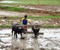
The monsoon rains are crucial for farm output and economic growth as about 55 per cent of the south Asian nation's arable land is rain-fed.

States have been told to prepare in advance to counter any impact of an adverse southwest monsoon.

The government declared Monday (Dec 4) a public holiday and urged private companies to encourage 'work from home' option for its employees in Chennai, Tiruvallur, Kancheepuram and Chengalpattu districts.

Some low-lying areas like the Andheri subway were submerged, forcing authorities to divert the traffic through alternate routes, civic officials said.

Reddy directed the officials to treat the storm as a major challenge to avoid loss of life and property as the winds are expected to blow gales reaching speeds of up to 110 kilometres per hour.

A deficient rainfall season starts with heavy showers.

Meteorologists earlier said Cyclone 'Biparjoy' had been impacting the intensity of the monsoon and that its onset over Kerala would be 'mild'.

More than 39.8 lakh people in 27 of the 33 districts in the state were affected by the deluge on Thursday.

The southwest monsoon is set to make its exit in style, bringing rains to the parched parts of Uttar Pradesh and Bihar, as weather forecasters have picked up signs of formation of a cyclonic circulation over Bay of Bengal. Addressing a press conference in New Delhi, India Meteorological Department (IMD) director general Mrutyunjay Mohapatra on Thursday junked last week's forecast of early withdrawal of southwest monsoon and announced the extended stay of the seasonal showers. "Even though we expected early withdrawal of the southwest monsoon, a cyclonic circulation over west-central and adjoining northwest Bay of Bengal will shift the monsoon trough southwards around September 7.

The IMD has fancy weather-monitoring radars in the name of providing better forecasts.

While the city received some showers late Wednesday night, it remained almost dry on Thursday.

This is the first cyclone in the Bay of Bengal this pre-monsoon season.

The India meteorological department said another western disturbance is likely to bring storms and rain to the northern plains, including Delhi, over the next few days.

After churning across the Arabian Sea for more than 10 days, Biparjoy made landfall near Jakhau Port in Gujarat on Thursday.